Simon Willison 借助 GPT-5.6-Sol 与 Claude Code 构建 GeoJSON Map Viewer 工具

内容摘要
Simon Willison在帮助Natalie收集地方政治边界地图时,发现需要展示GeoJSON文件并在地图上导出为PNG格式。他向GPT-5.6-Sol寻求工具建议,并主动构建了一个工具。经过使用Claude Code和Fable 5.1进行多次迭代,最终完成了这个工具。GeoJSON数据的获取是通过请求ChatGPT Work提供边界信息,它能够从不同政府数据源提取和组合文件,构建所需的数据。Simon通过ChatGPT Work获取了El Granada GCSD和MCC的边界数据,并在新开发的GeoJSON地图查看工具上展示了这些数据。

I was helping Natalie gather some maps of local political boundaries (for the Granada Community Services District and the Midcoast Community Council and found a need to display some GeoJSON files on a map and export that as a PNG. I asked GPT-5.6-Sol for suggestions of tools and it proactively built one. After some iterations using Claude Code for web and Fable 5.1 we got to this finished tool.

As for the GeoJSON.. it turns out if you ask ChatGPT Work to provide boundaries for almost anything it will churn away extracting and combining files from different Government data sources and build exactly what you need.

I got this polygon from:

I want a polygon that represents the exact boundary of the El Granada GCSD

And this one from:

Get me a GeoJSON file for the boundary (or boundaries if that makes sense) for the MCC - Midcoast Community Council - that operates near Half Moon Bay CA

Here's a link that displays both of them at the same time on the new GeoJSON map viewing tool.
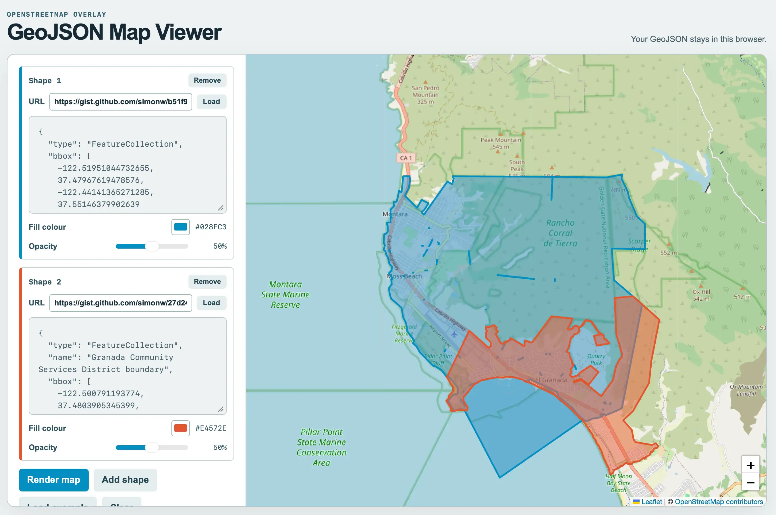
Screenshot of a web app with a left sidebar of controls and a large map on the right. Top left: OPENSTREETMAP OVERLAY GeoJSON Map Viewer. Top right: Your GeoJSON stays in this browser. Sidebar Shape 1 panel with blue accent: Shape 1, Remove button, URL https://gist.github.com/simonw/b51f9 with Load button, textarea containing { "type": "FeatureCollection", "bbox": -122.51951044732655, 37.47967619478576, -122.44141365271285, 37.55146379902639, Fill colour #028FC3 with blue swatch, Opacity slider at 50%. Shape 2 panel with red accent: Shape 2, Remove button, URL https://gist.github.com/simonw/27d24 with Load button, textarea containing { "type": "FeatureCollection", "name": "Granada Community Services District boundary", "bbox": -122.500791193774, 37.4803905345399, Fill colour #E4572E with red swatch, Opacity slider at 50%. Buttons: Render map, Add shape, Load example, Clear. The map shows the coast around Montara, Moss Beach, El Granada and Half Moon Bay with a large semi-transparent blue polygon covering Montara, Moss Beach and Rancho Corral de Tierra extending into the ocean, and an overlapping red polygon covering El Granada and Quarry Park. Map labels include Cabrillo Highway, San Pedro Mountain 325 m, Peak Mountain 545 m, South Peak, CA 1, Montara, Rancho Corral de Tierra, Golden Gate National Recreation Area, 489 m, Scarper Ridge, 552 m, Moss Beach, Montara State Marine Reserve, Ox Hill 542 m, 512 m, Fitzgerald Marine Reserve, Airport Street, Pillar Point Bluff, Quarry Park, El Granada, Pillar Point State Marine Conservation Area, Ox Mountain Landfill, Half Moon Bay State Beach, plus and minus zoom buttons, and attribution Leaflet | © OpenStreetMap contributors.

Tags: geospatial, tools, geojson

原始发布方:Simon Willison 博客

原文时间:2026-09-02 02:05:45 +08:00

阅读原文 · 数据来源:AIHOT

提示

本文用于信息整理与经验分享。第三方订阅、支付及账号服务可能调整,实际规则、价格和可用性请以下单页面及服务方最新说明为准。

咨询 GPT 充值咨询充值